|
|

|
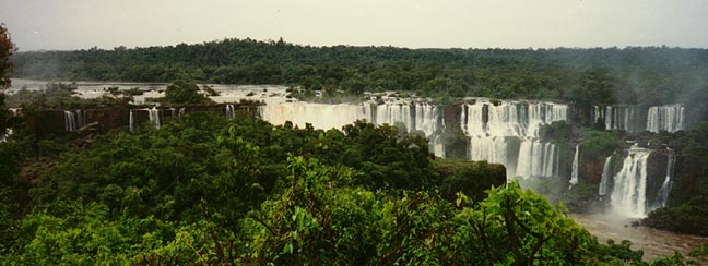
| Iguacu Falls -- Galen Frysinger Photo |

Navigate to Maps of Latin America
Overview
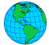
Latin America is the name applied to the part of the Western
Hemisphere to the southeast of the United States. It includes: Middle America, Central America, South America,
and the West Indies and Bahama islands.
The name Latin America derives from the languages spoken widely in the region -- Spanish,
Portuguese, and French. Another contributing factor is the 'Latin' culture of the Mediterranean brought here by Portugal
and Spain.
Middle America is made up of Mexico, Central America, and the islands called the Antilles.
Central America includes the countries south of Mexico through Panama.
The Islands are made up of the Greater Antilles (Cuba-Hispaniola-Puerto Rico and Jamaica)
and Lesser Antilles (the smaller islands of the Caribbean) and the Bahamas.
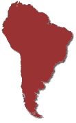
South America occupies the southern part of Latin America.
The topography of South America is somewhat reminiscent of that North America -- high
mountains in the west, and low mountains and hills in the east. Plains lie in between.
The Andes Mountains lie along western South America -- a narrow but formidable barrier
between west and east.
The highlands of the east -- the Guiana Highlands and Brazilian Highlands are areas
of ancient crystalline rock similar to the Canadian Shield.
Landforms of the southwestern United States continue into Mexico terminating in a volcanic
belt at 20 degrees north latitude. Ash from these volcanoes produces a fertile soil.
Central America and the Antilles are mostly mountainous due to action along crustal
plate boundaries. Several active volcanoes can be found here.
Platforms of raised coral limestone form the Yucatan Peninsula, Cuba, and the Bahamas.
A great deal of Latin America lies in the tropics -- between 30N and 30S -- it is in
these areas the highest temperatures occur -- temperatures near the equator tend to be much lower, owing to the presence of
clouds and rain many days of the year.
The warm temperatures and rainfall encourage the growing of tropical crops to be sold
in cooler Northern countries.
The southern extention of South America goes beyond 50 degrees south -- here, the landmass
becomes much more narrow and oceanic influences preclude the development of continental type climates.
Cold air masses from Antarctica collide with subtropical airmasses producing a world-wide
belt of stormy weather called the Roaring Forties.
Dry climates occur along the west coast of South America because of rainshadow effect
of the Andes and a cold current along the shore -- and also in Southern Argentian -- again, a rainshadow effect east of the
Andes. A transition of wind belts is the reason for the reversal of dry climate from side to side of the Andes -- Trade
Winds to the north; Westerlies to the south.
Central Chile has Mediterranean climate which grades into Marine in the southern parts
of the country.
The first people to inhabit this region came across the Bering
Land Bridge and spread to the southern parts of South America. Two of the world's six early civilizations were in this
region.
The Europeans were the second group of people to come to the region -- the Spanish and
the Portuguese. They and others controlled much of the region until well into the 19th century.
Today, much of the influence brought by the Europeans remains -- an emphasis on plantation
agriculture for export crops and mineral production for export.
Latin America is a leading producer of coffee, sugar, bananas, spices, cacao, cotton,
and exporter of oil, managanese, tin, and copper.
Industrialization was slow to develop but has grown significantly in Mexico, Brazil,
and Argentina.

Physical Geography
The surface of Middle America is made up of a huge plateau
and mountains -- an extention southward of the landforms of the United States. Most of the people live in these higher
areas of cooler and drier climate. The topography has been formed by the collisions of crustal plates; earthquakes and
volcanic activity are common throughout the region. The Caribbean Islands mark the edge of a plate and have been formed
by both tectonic and volcanic activity.
The Andes Mountains are a dominant feature of South America. They too are the result
of plate collisions folding, faulting, and creating volcanic activity. These are the world's longest mountain range
and include some of the world's highest mountain peaks. They create an intense barrier between the west coast of South
America and the rest of the continent
In eastern South America are two Highland areas of ancient crystalline rock -- the Guiana
Highlands, and the Brazilian Highlands. The Brazilian Highland is noted for its great mineral wealth and associated
manufacturing activities.
Almost half of South America is covered by plains. The most important are the
Llanos, Amazon, and Parana-Paraguay plains.
The Llanos are also known as the Plains of the Orinoco -- this is a grassland area largely
in Venezuela and Colombia. The Amazon Plains are centered in Brazil and reach into ajoining countries. The Amazon
Plain region is dense rainforest. The Parana-Paraguay plains are more commonly called the Pampas -- this is a region
of rich soil Humid Subtropical climate and agriculture. The northern extension of the Parana-Paraguay plain is the Gran
Chaco -- a region of intense rain in the summer months and equally intense drought in the winter.
The three great river systems of South America are the Amazon, Plata, and Orinoco.
The Amazon is the world's greatest river, rising in the Peruvian Andes and flowing nearly 4000 miles to the Atlantic Ocean.
It plus its tributaries create a transportation network of some 25,000 miles.
The Plata System includes the Parana, Paraguay, and Uruguay rivers -- it is the most
important system for commercial transportation in Latin America. The Plata system connects Uruguay, Argentina, Bolivia,
Paraguay and Brazil.
The Orinoco river in northern South America has little commercial shipping.

Climate
Tropical Rainforest -- Temperatures
here average nearly 80F every month of the year. Owing to the presence of the ITC (Intertropical Convergence Zone)
rainfall is heavy and humidity high. This climate is found in the Amazon Basin and many tropical lowlands of Latin America.
The high heat and humidity, insects, and disease limit population in these areas.
Tropical Savanna -- This climate zone develops north and
south of the rainforest. It is a tropical wet and dry climate -- the ITC is overhead in the summer months but moves
away in winter causing drought conditions. Savannas are essentially grasslands with a scattering of trees.
Humid Subtropical -- This climate is in southeastern
South America where onshore winds from the Atlantic bring rain thoughout the year. The Pampas is a great agricultural
area as a result -- and this is one of the most densely populated areas of South America.
Desert -- The coastal desert of Peru and Chile results
from winds from the east which drop their moisture before crossing the Andes. Winds on the Pacific side come from the
south and southwest, but cross the cold Peru Current and pick up little moisture.
Another desert region lies east of the Andes in Argentina. Winds from the west
ascend the Andes creating marine climate in Chile -- a rainshadow develops on the lee side of the Andes across the Patagonian
Plateau.
Mediterranean -- This climate occurs in central Chile.
Summers are sunny and warm, but with little rain. Subtropical high air pressure covers the region at this time. In winter,
the high pressure moves to the north allowing moisture bearing storms in the westerlies to invade the area. This is
a great agricultural area, and home to 90% of the population.
Marine -- Southern Chile has a cool climate with heavy
rains. Westerlie winds blow onshore. This is a region of forests and sheep production.
Highland Climate -- In the mountains of Latin America,
climate often depends on altitude. Coastal lowlands may be hot and humid but an increase in elevation brings cooler
and drier conditions. Many of Latin America's people live in areas of Highland Climate.
Caribbean Weather Satellite
South America Weather Satellite
Animated Climatic Map
Resources
Agriculture
Bananas -- Latin America is the leading banana producer
of the world. Plantations are located in protected areas where strong winds will not blow the top-heavy plants over.
A typical crop takes 12 to 15 months to maturity. The invention of the refrigerated ship has greatly expanded production.
Sugar -- Cuba, Brazil, Mexico, and Puerto Rico are major
producers. This crop requires heavy rainfall, bright sunshine, fertile soil, and high temperatures. Sugar is widely
produced on many of the Caribbean Islands. Sugarcane requires 12 to 24 months to reach maturity.
Cacao -- Used for cocoa and chocolate. This crop
requires fertile soil, high temperatures, and heavy rainfall -- found in the hot rainy coastal lowlands. Venezuela and
Brazil are major Latin American producers.
Coffee -- Most of the world's coffee is grown in
Latin America. Brazil is by far the greatest producer in an area surrounding Sao Paulo
Other major producers are Colombia, El Salvador, Guatemala, Mexico, Costa Rica and Ecuador.
Cattle and Wheat -- The fertile soil of the Pampa has helped
Argentina become a leading exporter of both. Brazil is also a major cattle producer.
Sheep -- Argentina and Uruguay are among the world's leading
sheep producing countries. Sheep are raised on the Pampas, northeastern Argentina, and on drier lands west and south of the
Pampas.
Cotton -- Brazil, Mexico, and Peru are major producers.
Corn -- Corn is a major food crop in Latin America and
has been grown here for hundreds of years. Brazil, Mexico, and Argentina are the leading producers. Uses range
from livestock feed in Brazil, to food for the people in Mexico, to an export commodity in Argentina.
Other Products -- Henequen is a fiber crop used in rope
and twine raised on the Yucatan Peninsula of Mexico. Sapodilla trees supply chicle used in chewing gum. Natural
rubber is produced only in small quantities -- but it was first found in Latin America. Brazil and Colombia produce small
quantities.
Forests
Almost half of Latin America is forested -- much of this is in Brazil. Both soft
and hardwoods are found. A problem in development is distance to market -- many of the forests are too remote for ultilizaton.
Brazil has forests of mahogany, ebony, cedar, and Parana pine, but supplies little to world markets. Argentina has Quebracho
trees used as a source of tannin to cure leather -- its resistance to decay makes it ideal for fenceposts and railroad ties.
Yerbe Mate leaves are used to make a tea-like drink. Other forest products include rubber, carnauba wax, Brazil nuts,
and chicle.
Water Power
Heavy rains, mountains and plateaus, give Latin America tremendous water power potential.
Most locations are far from population centers which has hindered development. A recent project on the Parana river
at Iguacu Falls provides enormous amount of energy to Brazil and Argentina.
Mineral Resources
Copper -- Chile has huge copper deposits and is a
major export.
Petroleum -- Venezuela is a major producer from oil
pools below Lake Maracaibo. Mexico is believed to have reserves possibly rivaling those of the Middle East. Other
producers are Argentina, Colombia, Trinidad and Tobago, Brazil, Ecuador and Peru.
Tin -- Tin is used as a ingrediant in alloys such as bronze.
Bolivia is a major producer.
Iron -- Major producers are Brazil, Venezuela, Chile
and Peru.
Bauxite -- The ore of aluminum is mined in Jamaica, Suriname,
and Guyana. Most is shipped to the United States and Canada to be refined with their hydroelectric power resources.
Other Minerals -- Manganese
is used to make steel harder -- Brazil is a world leader in mining manganese. Antimony
is used in pewter, paint pigment, and combined with lead to form telephone cable casings, it is mined in Bolivia, Mexico,
and Peru. Silver is mined in Mexico and Peru. Platinum is used in jewelry and
as a catalyst in chemical reactions -- Colombia is a leading producer. Natural Asphalt is mined from
Pitch Lake on the island of Trinidad.

Manufacturing
Manufacturing has grown slowly in much of Latin America --
exceptions are Mexico, Brazil, and Argentina.
Among the reasons for this are a lack of coal (to fuel the industries), little money
to invest in industrial infrastructure, a shortage of skilled workers, poor transportation systems, limited home markets,
and unstable governments.
Historically, wealth was measured in how much land was owned -- which meant the wealthy
landowners invested in more land not in industrializing their countries.
Today this is changing as more and more countries seek to industrialize.
Geography 101 -- Middle America
Geography 101 -- South America
South America -- Infoplease
CIA World Factbook
Elevation Zones
Andes Mountains
Amazon Basin Interactive Web Site
Llanos of Venezuela
Christopher Columbus
Precipitation Pattern
Plata River System
Learn More About Bananas
Coffee
Sugarcane and the Americas
Population Distribution
Panama Canal and Live Webcam
General Motors Latin American Operations
Ford Motor Company Latin American Operations
Daimler-Chrysler Latin American Operations
Galen Frysinger Photos
Virtual Tour of Mexico City
Map and Discussion
Tour of Latin American Language and Culture
Mayan Civilization
Aztec Civilization
Inca Civilization
Angel Falls
Tierra del Fuego
Pan American Highway
|
|
|